
Welcome to the NSF Supported NCALM Data Distribution Center
For the main NCALM website please visit: NCALM
This site provides public access to high-resolution airborne laser swath mapping data (ALSM) acquired by NCALM for NSF sponsored research projects.
You can visualize the location of the available projects and download data files using a Google Earth interface. The interface also provides on the fly, multi-resolution shaded relief overlays for the LIDAR DEM that can be used to preview the data and see the accurate extent of the dataset.
The Google Earth KML file can be used off-line to browse project locations and meta-data (Internet connection required for the overlays).
| Download the LIDAR Data Distribution KML |
| Download Google Earth here |
![]() Additional Datasets
Additional Datasets
The following datasets collected and processed by NCALM are available through OpenTopography.org
| B4: Southern San Andreas & San Jacinto Faults LiDAR data of the B4 Southern San Andreas Fault as part of the 'B4 Project'. |
| EarthScope Northern California Includes the San Andreas, San Gregorio, Hayward, Calaveras, Rodger Creek, Maacama, Green Valley, and Little Salmon faults. |
| EarthScope Intermountain Seismic Belt Includes portions of Yellowstone and Teton National Parks and the Nephi segment of the Wasatch fault. |
| EarthScope Southern & Eastern California Includes the Garlock, Elsinore, Burro Flat San Andreas, and Owens Valley faults. |
| EarthScope Alaska Denali Totschunda Includes Central and Eastern Denali and Totschunda faults. |
| EarthScope Yakima Includes data along the Yakima River in Central Washington. |
![]()
How to use the NCALM LIDAR Data Distribution KML
Note:Please check the KML for a complete list of projects. The live KML file may contain more projects than what's shown in the following screenshots.
Place your mouse over the images to get aditional information.
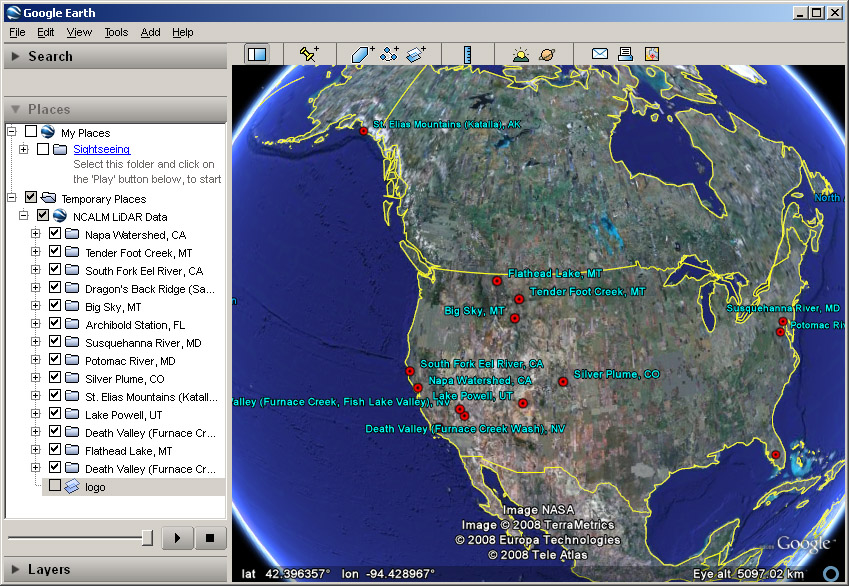
1. Select a project from the list or zoom in the desired location
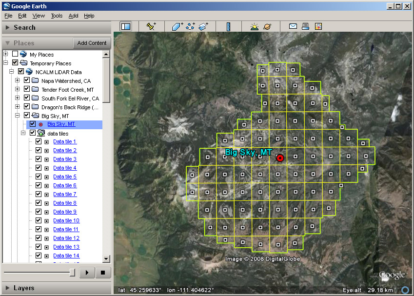
2. Zoom in to reveal data tiles. Click on project (red dot) or tile (black/white square) placemark to access aditional functionality
Usage tips
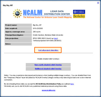 |
Batch download all project tiles You can access the "List all project data tiles" from both the main project's placemark ballon as well as from individual tile placemarks (project placemark ballon shown on the left). This special page lists all available data tiles for the selected project in one webpage for easy batch downloading. You can download the tiles one by one or by using your favorite download manager program. |
|
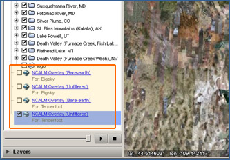
Manage shaded relief overlays By default Google Earth will place the shaded relief overlays you open at the bottom of the "Places" panel layers list. The overlay's name indicates if it is a bare-earth or unfiltered shaded relief image, while the description indicates which project the overlay belongs to. Disable or remove overlays if Google Earth's perfomance is affected by the number of overlays opened. |
The NCALM Distribution Center is hosted and maintained at UC Berkeley, Department of Earth & Planetary Science,
with IT infrastructure support from the Berkeley Seismological Lab
