Figure21

Back Home


Title Page
Preface
Background
Conceptual Framework
Theory
Application
Testing
Prescriptive Use
Conclusion
References
Table3
Figure Captions
Figure1
Figure2a
Figure2b
Figure3
Figure4
Figure5
Figure6
Figure7
Figure8a
Figure8b
Figure9
Figure10
Figure11
Figure12a
Figure12b
Figure13
Figure14
Figure15
Figure16
Figure17a
Figure17b
Figure18
Figure19
Figure20
Figure21

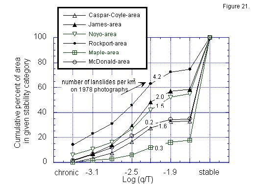
Figure 21. Cumulative percent of the watershed area in corresponding log(q/T) slope stability categories for 6 watersheds in Northern California. Numbers on the curves record the number of landslides per km2 of the entire drainage basin mapped by John Coyle from 1978 aerial photographs.

 figure21.gif (10289 bytes)


Copyright 1998, William Dietrich and David Montgomery
For problems or questions regarding this web contact bill@geomorph.berkeley.edu.
Last updated: November 01, 1998.